
Our bleary eyes and drowsy heads from the six-hour red-eye road trip from Manila to San Andres, Quezon was suddenly shook awake. We knew we would take a motorbike to our first destination which is Tigbi Falls, but I guess we were not ready for the tough and rough road (which is an understatement) ahead. Suddenly, I was harkened back to those butt-beating rides to waterfalls like in Asik-asik Falls in Cotabato and Tulgao Palan-ah Falls in Kalinga. While it’s certainly not of the same level of difficulty, it is that close to a tough ride in at least half an hour for me to recall them. But all that was a rewarding transit. Aside from the scenic landscape of Banaba village on the way, Tigbi Falls is where stuff of enchantments and lore are born.

Road to Tigbi Falls
Where is Tigbi Falls exactly? Since this is a side-trip from a more popular destination, the Alibijaban Island in San Andres, Quezon, it seems common knowledge that the falls is under the same municipality. In fact, its common name for the locals is Banaba Falls which is a Barangay in San Andres. But the jump-off point goes through Baranggay Mabunga which is already on the next municipality of San Francisco. I asked several of our motorbike drivers where exactly the falls fall under, the closest answer I could accept is that it’s at the border of both San Andres and San Francisco. Going by GPS and the geotag of my photos which I know isn’t exactly accurate, the location from google indicates that the spot is under San Andres.

Wondrous Levels
No matter where it’s at, we had to hike about 30 minutes to reach the falls. We had to pass through a couple of streams and walk through soft soil and evergreen trail along a river. I thought the hike was easy to moderate but can get really difficult if it rains as it gets really muddy and slippery.
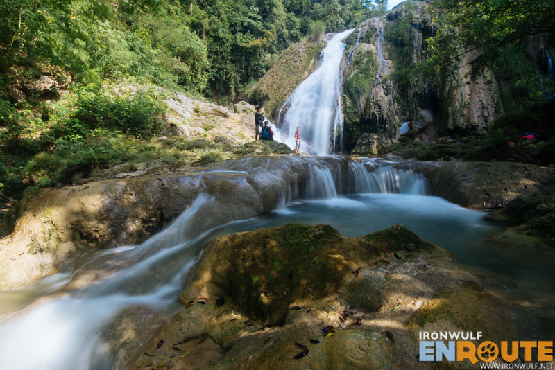
The firs level we could see the the cascades already getting stronger. There’s a nice small cascade on the left as we enter the trail. Then we had to navigate the side of the falls to go down. I noticed that the locals have already carved some steps on the rocks to make it easier to descend amidst the gushing water. I thought this wide curtain of a falls was already the main falls but its not.

More photos and essential info on the next page…

Ferdz Decena is an award-winning travel photographer, writer and blogger. His works has found print in publications such as Singapore Airlines’s Silver Kris, Philippine Airlines’ Mabuhay, Cebu Pacific’s Smile and Seair InFlight. He has also lent his expertise to various organizations like the Oceana Philippines, Lopez Group Foundation, Save the Children and World Vision, contributing quality images for their marketing materials.