Benguet | Mt Ulap Eco-Trail: A Trek Through the Clouds

At the Abanao Poaoy of the Mt Ulap Eco-Trail

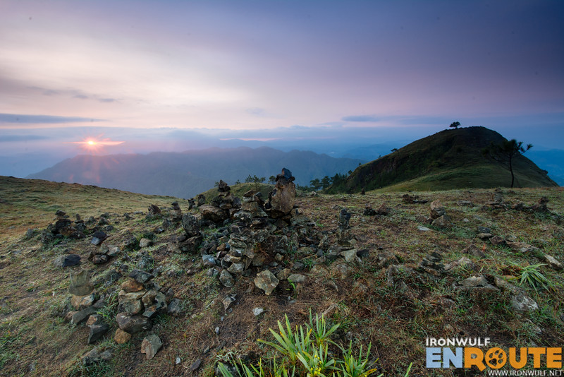
Clouds have always been a thing of fascination. People climb mountains often to see the play of clouds billow across mountain peaks like waves. Dissipating in a dance from nebulous to nothingness. When I heard about the Mt Ulap Eco-Trail which recently opened last October 2015, I was intrigued. The Eco-trail is also known as the Philex Ridge, named after the huge mining company operating in the area. The highest peak, was named Mt Ulap by an engineer named “Lagman” who marked the summit in February 1, 1939. He described that the mountain is perennially a magnet for clouds (which is “ulap” in tagalog). The trail has long been a playground for trail runners from Baguio and Benguet. Now the local government, particularly the Ampucao Tourism Council opened the trail to the public.

Continue Reading

Bontoc | Humuyyo Falls in Talubin, The Land of Clear Waters

The highest waterfalls in Bontoc, the Hamuyyo Falls

Bontoc is such an underrated destination in the Mountain Province region. I must admit that I was guilty of dismissing Bontoc as simply a gateway to other destinations like Sagada, Banaue or Kalinga. Discovering the beauty of Maligcong three years ago changed my notion of Bontoc. I realized, the town is just the tip of the iceberg. My recent visit found me in Talubin, the neighboring village 6km from Bontoc Town proper, known as the Land of Clear Waters in the province. One look into the village, it’s easy to see the abundance of water flowing through the village. Talubin village is settled comfortably at the slopes of the Cordillera Mountain Ranges where streams from the mossy forest continuously flow and a clean river runs through. We were also there to visit one of the main source of water in Bontoc, the Humuyyo Falls, located 3,700 feet above sea level.

Continue Reading

Romblon | Aglicay Beach Resort Tablas: Where Nature Abound

My motorbike ride roared through the narrow ascending road hugging the side of the hills. It’s always exciting to step on a new island. In this case, my feet, are finally grounded on Tablas Island, the largest of the three major islands in Romblon province. I flew into the island via PAL and landed at Tugdon airport. My motorbike is taking me to Aglicay Beach Resort in the neighboring town of Alcantara. My eyes were constantly peeled as I absorbed the idyllic landscape of this island countryside. We got off the main road and saw a sign “4km to Aglicay …

Continue Reading

California | Torrey Pines State Reserve Trail Hike and Beach Time

Descending at the Torrey PInes State Reserve Beach trail with stunning rock formations

The day started with an amusing little chaos. It’s funny how logistics can quickly screw up at times. The plan was to spend time with relatives at La Jolla Cove not really Torrey Pines State Reserve. My sister and I took the AmTrak train from Vista to San Diego where our cousin picked us up at the Old Town Station to meet up with the rest of our cousins. A little misunderstanding went us driving around in circles at the upscale neighborhood of La Jolla. And when we finally got to meet heads with other relatives and laid our options did we get a clear direction where we’re going. Everyone agreed we’ll visit Torrey Pines State Reserve for the rest of the afternoon. I was excited as I’ve been yearning to do some trail hikes in San Diego since I came in the USA. That’s one of the things I like about in the country, the importance of parks and reserves and their accessibility in the city.

Continue Reading

El Nido | Bike and Climb to Mt Mansilawit Pasadeña

The mountain’s Hersheys chocolate kisses-like shape makes it an eye-catching roadside attraction when passing through the main highway of Pasadeña to Barotuan, about 12km north of El Nido from the town center. But it took a while before someone conquered the summit of Mt Mansilawit despite its low elevation as there were tales of giant snakes and notorious monkeys living on this mountain. Pasadeña Native couple, Sylvia and Alex were brave enough to explore and are now lead guides to share the wonders of this little mountain. I decided to bike here from town since I’ve been curious about this mountain and I thought biking would be the best way to see other places en route. It took me almost an hour to reach the signage pointing the way to the mountain.

Continue Reading

Sagada | Traverse to the Blue Soil Hills, Kaipitan and Balangagan Cave

“Wow! How does one get there?” I asked my companion Norbs while pointing down on a parallel electric line post way down below. It seemed so far and unreachable from where we were at Kamanbaneng Peak or popularly named Marlboro Mountain. After enjoying a wonderful play of billowing clouds after the sunrise, we were set for a long trek southwards of Sagada. It was a beautiful day for a trek but the rains the day before had dampened the ground making it more sticky and on some parts muddy. But after a few hours, we found ourselves below the electric line I was pointing to earlier but standing on the curious hues of the Blue Soil Hills of Sagada.

Continue Reading

Sagada | Kamanbaneng Peak: Chilly Sunrise at the Marlboro Mountain

I never get tired of Sagada. Even if go back to the same places I visited there again and again, even if there were hassles or inconveniences encountered going there, the allure never fades. On my recent trip to Sagada, I wanted to venture further and explore the “new” sites recently opened for exploration. My friends and I visited SAGGAS (Sagada Genuine Guides Association) office and was greeted by the jovial, Yaki. We were inquiring about a particular tour but curiosity led us to change plans seeing the map on their wall. We decided to head east then traverse southeast of Sagada going along the border of Alab down south. Our first stop is Kamanbaneng Peak, one of the alternative sunrise destination in Sagada.

Continue Reading